-
English (US)
Choose your OTT HydroMet brand and region:


Six universities from South Africa, and one each from Île de la Réunion (Reunion Island) and Botswana, are cooperating in the Southern African Universities Radiometric Network (SAURAN), to promote the use of solar energy in the Southern Africa Development Community (SADC) countries, and to improve the quality of satellite-derived solar data available for the area.
The network consists of twelve radiometric measurement stations in Southern Africa and one on Reunion Island, all equipped with high resolution instrumentation to measure the solar irradiance as well as other meteorological parameters.
The data has been made publicly available for free download. In early 2015, three more stations will be added to the SAURAN network. One located in Namibia and the other two in South Africa.
The measurement network was initiated by the Universities of Stellenbosch and KwaZulu-Natal.
The network was further extended to Port Elizabeth, Pretoria, Graaff-Reinet, Vryheid, Bloemfontein, Vanrhynsdorp, Richtersveld and more. Some of the stations are installed at University campuses while others are located on private farmland. In 2014, the station at the University of Reunion was installed.
The main purpose of placing the measured data in the public domain was to make it possible for companies and members of the public to obtain accurate, measured solar data in the areas where the stations are deployed.
In addition, the data was made available to institutions who predict solar irradiance through satellite imagery to recalibrate their estimation models so that the overall quality of satellite-derived solar data will improve.
At present it is possible to obtain solar data for periods of up to 20 years from some of these sources. Now, the accuracy of these satellite-derived data sets can be verified against actual local measurements of solar radiation.
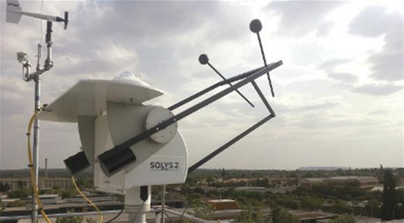
Most of the ground stations in the SAURAN network use Kipp & Zonen SOLYS 2 sun trackers fitted with CMP 11 pyranometers for global and diffuse horizontal irradiance measurements, and CHP 1 pyrheliometers for direct normal irradiance.
All radiometric data are time-averaged over one minute, hourly and daily periods. Instruments are subject to regular maintenance and all glass domes and windows are cleaned multiple times each week.
The majority of the stations were installed, and are maintained, by GeoSUN Africa, a spin-off company from the University of Stellenbosch: http://geosun.co.za
Through a project at Stellenbosch University, six of the SAURAN stations were funded by the German Federal Enterprise for International Cooperation (GIZ).
GIZ also funded updated Direct Normal Irradiance and Global Horizontal Irradiance solar resource maps based on the data from these and the additional six stations. GeoModel Solar of Slovakia provided the satellite modelling on which the maps are based.
| |
More maps, data and information can be accessed at: www.sauran.net
Article by Prof. Wikus van Niekerk, Director of the Centre for Renewable and Sustainable Energy Studies, University of StellenboschRelated Product.